CDN NEWS |
  US NEWS


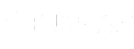
The winter season has now passed, and we are again heading into the annual freshet (runoff) period. Snow accumulation has reached its peak, for the most part, with sporadic spring storms adding a bit more here and there along the eastern slopes of the Rocky Mountains and across the Plains region. The accumulations that have occurred this year have been about average compared to previous years, with much of the central and southern areas of Alberta seeing between 85-115% of normal conditions (Figure 1). Other than the northern half of the province, the prairie snowpack has already melted in most areas. Spring storms are still generating some snow to local regions, but this will soon shift to rain-dominated storms as the spring season advances towards summer.
Figure 1. Winter precipitation in Alberta as a percent of normal conditions and spring Runoff Potential for April 20211.
Although the snowpack this year has been “average”, or slightly above, the risk of flooding still exists. Given the right conditions, rain-on-snow events can cause events in streams draining headwater areas serviced by higher altitude snowpacks. It is still too early to tell how this will play out, but those situated in areas at risk should monitor local weather conditions as we head into the rainy season. Although stream hydrographs are not showing the commencement of freshet conditions yet, this will change over the coming weeks as warmer conditions establish and the mountain snowpack ablates. If persistently warm weather conditions establish, similar to what we experienced in the early part of April, this will inevitably raise the flood risk.
However, the long-range forecasts provided by the National Oceanic and Atmospheric Administration (NOAA) is for the continued presence of La Niña conditions that are expected to transition to ENSO2-neutral during the May-July timeframe. La Nina conditions could mean a wetter than normal spring, but this will play itself out over the coming weeks.
Longer-term drought risk
According to the North American Drought Monitor, a significant area of the United States and parts southern Canada are currently experiencing moderate to severe drought conditions (Figure 2). This is happening mostly across portions of California, Colorado, and west Texas where conditions are extreme to exceptional. The hardest hit states appear to be the usual suspects: Nevada, Utah, Arizona, and New Mexico. If this trend continues, it will certainly have negative ramifications for those states.
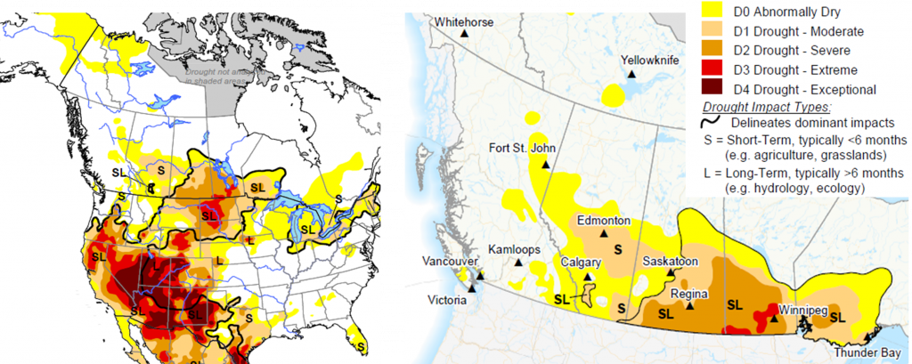
Figure 2. Drought conditions in North America3 (left) and Western Canada4 (right), in particular, as of March 31, 2021.
As for Canada, the southern portions of Manitoba and Saskatchewan are currently experiencing drought conditions of severe to extreme that will likely hamper crop production unless conditions change significantly (Figure 2). Alberta appears to be suffering to a lesser degree; however, significant areas through the central part of the province as well as in the Calgary-Lethbridge corridor and Medicine Hat regions are experiencing well-established moderate drought to abnormally dry conditions. Meanwhile, British Columbia appears to be emerging unscathed thus far, with only abnormally dry conditions in isolated regions of the province.
The persistence of dry conditions will depend on the patterns of sea surface temperature and sea level pressure that control the position of the jet stream and the spring and summer storms tracking across the western states and provinces. Those individuals and businesses located in areas suffering from a prolonged deficit of moisture should be prepared for extended low flows in local rivers and streams, particularly those originating in the southern Plains region. This might mean changing the usual diversion and storage strategies to ensure adequate supplies of water through the year. The annual wet season will dictate how things turn out, as reliance on later season convective “hit and miss” storms may not provide the level of security necessary to ensure adequate water supplies for communities and businesses. If conditions shift from ENSO-neutral towards an El Niño phase (i.e., warmer and drier) this could further strain already challenging sustainability efforts.
Did you know…?
Climate modelling shows that the occurrence of extreme events, like floods and droughts, is projected to increase in the coming years. This will have ramifications for projects and infrastructure located in high risk areas, but the question is “where are the high risk areas?”. Knowing your water security is important, particularly when your enterprise depends on it.
Integrated Sustainability has been helping clients navigate the challenging early spring flow conditions by proactive planning for upset conditions. We have developed several water security plans and corporate sustainability strategies to guard against business interruptions from erratic conditions in challenging watersheds.
Integrated Sustainability’s water monitoring telemetry and data management software brand, Random Acronym, can support your water strategy and ensure that agile decisions can be made and operational risk can effectively be mitigated. Random Acronym offers FieldTracker, a streamlined, affordable, and flexible hardware and software solution designed to be easy to deploy in remote locations.
The self powered telemetry hardware works with a range of sensors, including flowmeters and level sensors, automatizing water data collection and delivery. Capable of autonomous operation for up to 5 years and portable enough to easily be redeployed when need, the hardware uses both cell and Satellite to transfer data securely. The mobile friendly web application presents high level overviews, detailed charts and tables, as well as alarms and alerts to manage critical early warnings.
Whether you want to read flow volumes and rates through a pipeline, storage volumes on a pond or c-rings, or monitor river levels for either compliance or early flood warning, FieldTracker can make remote data easy.
Do you need?
Planning for the worst will ensure success in an ever-changing world. We know and understand the latest climate projections and what they mean for water-reliant activities and the related risks. Let us help you manage uncertainty through proactive water risk assessment and security planning so that you can address the future with confidence.
Questions? Contact Us.
Jon Fennell, M.Sc., Ph.D., P.Geol.
VP, Water Security & Climate Resiliency
587.891.5831
[email protected]
www.integratedsustainability.com
References:
2 El Niño Southern Oscillation: an irregular periodic variation in winds and sea surface temperatures over the tropical eastern Pacific Ocean, affecting the climate of much of the tropics and subtropics, as well as the Pacific Northwest. The warming phase of the sea temperature is known as El Niño and the cooling phase as La Niña. ENSO cycles have been shown to affect snowpack accumulations and streamflows in Western Canada, with El Niño bringing drier conditions, and La Niña the opposite.
3 https://www.ncdc.noaa.gov/temp-and-precip/drought/nadm/maps
4https://www.agr.gc.ca/atlas/maps_cartes/canadianDroughtMonitor/en/2021/cdm_2103_en.pdf
Share This: