CDN NEWS |
  US NEWS


![]()
How unifying land management and GIS analytics across its subsidiaries led a major utility holding company to greater efficiency and the discovery of lost revenue.
Identifying the Challenge
A large utility holding company serving millions of electric and natural gas customers throughout eight U.S. states needed a solution to consolidate and optimize its land asset management across its four wholly owned subsidiaries.
The electric utilities giant (hereafter referred to as the “Utility”) suffered from using disparate systems at each of its subsidiaries — an inefficient, siloed land asset management style that made enterprise-wide administration, analysis, and forecasting a significant challenge. Lacking a dependable, central database of land records increased the company’s risk, slowed operations, and hindered decision making.
“Our employees would do research and sometimes miss rights or get title opinions from lawyers on projects that were missing agreements,” said a Utility subsidiary’s Siting and Land Rights Manager as he recalled some of the difficulties they experienced.
Choosing a Tech Partner
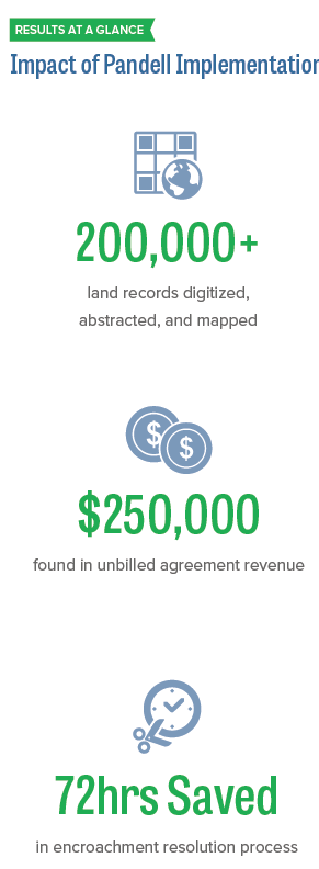
The Utility’s complex asset mix comprises more than 200,000 land records and includes property used for electrical transmission distribution, pipelines, and wind farms. Its array of land use agreements ranges from Army Corps of Engineers waterway permissions to gas well storage agreements, and some records are more than 100 years old.
With the goal of unifying its land management systems across the entire organization, the Utility selected Pandell’s land & GIS software and services because of its scalability, applicability to all divisions, and capability of handling any number or type of land agreement. The Utility also contracted Pandell’s land and GIS services team to digitize, abstract, and map its land records to achieve maximum return on software investment in the shortest possible time.
Upon implementation, Pandell’s integrated land management and GIS software offered the Utility’s employees instant access to land records held in a central database. This meant no matter which subsidiary the land parcel rights resided with, or where an employee worked, any securely authorized staff member could retrieve updated, accurate data. It also gave end users a convenient and intuitive dashboard to search, view, and edit land rights information. Generating insightful reports for C-suite executives became quick and easy.
The rewards of this decision surpass operational process improvements and time savings to include, in one notable case, the discovery of money owed to the company since the 1970s.
Starting with Accurate Data
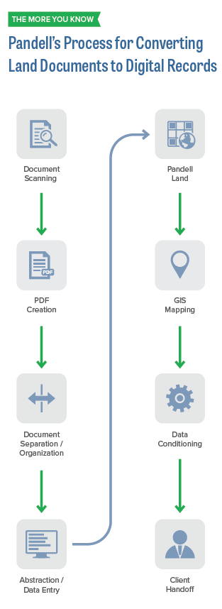
For any land system to serve as a single source of truth, it is key to start with clean data converted from original source documents. For efficiency, the Utility contracted Pandell’s land & GIS services team to digitize, abstract, and map its more than 200,000 land records.
“Our land and GIS teams are experts in Pandell software and its related business processes,” said Matt Kopycinski, Manager of Land & GIS Services at Pandell. “We can convert land documents to digital records in Pandell software more accurately and cost effectively than anyone, which takes pressure off our clients so they can focus on running their day-to-day business.”
Offloading the data conversion work to Pandell enabled the Utility to validate its data without infringing on its employees’ routine time and duties.
Integrating Systems
The system implementation included integrating the Utility’s new land & GIS software with its existing Esri ArcGIS™software, thus enabling the Utility to generate aerial and topographic maps of its facilities, contracts, and land position. Also, the Pandell land system was integrated with IBM Content Manager® to synchronize the Utility’s digital documents with corresponding land data.
The organization took the additional step of integrating its Pandell land system with its GE Smallworld™ facilities management system. This allowed real-time updates to land records with the latest information from Smallworld, which serves as the source of truth for information on the Utility’s transmission lines, towers, and poles.
Pandell’s land and GIS services team can digitize, abstract, and map land records in Pandell software more accurately and cost effectively than anyone else, ensuring companies achieve maximum return on their software investment in the shortest possible time.
Reaping ROW Rewards
Besides improving efficiencies to the Utility’s land management operations, the syncing of its back-office systems resulted in two major benefits to the enterprise — both having to do with rights of way.
The first was an improvement in its risk management. Previously, the Utility’s resolution of encroachment issues took up to three days from the time a field agent reported a potentially dangerous property development encroaching on a right of way, to someone back in the office sifting through thousands of documents to determine what action, if any, needed to be taken. With the process switching from paper to digital management, turnaround time shrunk to 30 minutes.
If you do not know what you own, there are no checks and balances to verify you’re getting paid what you’re owed.
— Utility Siting & Land Rights Manager
The other benefit was in bringing revenue-driving transparency and automation to the company’s ROW management. Through the process of digitizing old records, historical agreements were uncovered that could be acted on to generate revenue.
For example, it was reported that the company held an agreement from 1976 that allowed a university to build a parking lot extending into its right of way. The agreement stipulated a recurring payment would be made to the Utility by the university in exchange for the right to pour and use a concrete parking lot on the Utility’s land. However, without adequate monitoring of the agreement terms, the Utility never billed it out and the university never paid. Time passed, and no one at the company was even aware of the issue.
Implementing its new Pandell land system changed all that. The neglected agreement terms were discovered, and the overdue fees identified; a finding verified by the university itself. Since then, $250K in fees accumulated over four decades were subsequently billed to the university and paid in full.
“There are cost benefits you can realize outside of just efficiency,” commented the Utility subsidiary’s Siting and Land Rights Manager. “If you do not know what you own, there are no checks and balances to verify you’re getting paid what you’re owed. It was nearly impossible to track payments properly when we were manually tracking thousands of land agreements. Today we can confidently rely on automatic notifications in our Pandell land system to drive our billing processes.”
These sentiments were echoed by a senior company executive who indicated they have found more value in Pandell’s land and GIS software than they initially even anticipated. “By transforming our paper land files into digital ones and by giving our people the digital tools they need to track and locate information easily, our overhead cost savings far outweigh the cost of implementing the software across our enterprise,” said the executive. “We’ve established a new level of access, transparency, and efficiency that would not, or could not, be achieved previously.”
Who Uses Pandell?

About Pandell
Pandell is an industry leader in delivering Software-as-a-Service (SaaS) solutions 500+ energy companies in Canada, the USA, and abroad. Our customers range from startups to major enterprises across energy sectors including oil & gas, pipelines, utilities, mining, and renewable energy. Our cloud-hosted product suite helps finance, land, and field operations run their business more effectively; while our enterprise division builds and manages large-scale web portal applications that facilitate work across organizations. Combining the strength of our industry experience, Lithium™ technology, and practical software subscription model, we are Crafting the Future of Energy Software.
Visit www.pandell.com
Share This: