CDN NEWS |
  US NEWS








| Summary British Columbia’s unconventional gas sector is backed by one of the most comprehensive programs of public geoscience anywhere in the world. At the Geoscience BC Energy Webinar on June 22, Dr. Brad Hayes, Senior Geoscience Advisor at GLJ, presented evidence of how this research is delivering continuous improvement in water management, seismicity monitoring and carbon storage — the kind of progress that has earned broad public support. |
The resource
British Columbia holds one of the largest unconventional natural gas endowments in North America. At the Geoscience BC Energy Webinar on June 22, Dr. Brad Hayes, Senior Geoscience Advisor at GLJ, outlined the scale: the Montney Formation alone contains an estimated 449 trillion cubic feet (Tcf) of marketable gas. The Liard Basin adds 219 Tcf and the Horn River Basin another 78 Tcf.
To put those numbers in context, Canada produces roughly seven Tcf of natural gas per year. The Montney’s 449 Tcf represents more than 60 years of the country’s entire annual production from a single formation in one province.
Accessing these resources requires horizontal drilling and multi-stage hydraulic fracturing — the technologies that unlocked tight gas and shale gas across North America beginning in the early 2000s. The resource base was delineated through collaborative work by industry, academia, B.C.’s Ministry of Energy, Mines and Petroleum Resources and the Geological Survey of Canada.
Dr. Hayes’s presentation drew on research funded and co-ordinated by Geoscience BC to show how this resource base is being developed with continuous improvement in three areas: water management, seismicity monitoring and carbon storage. The story is one of science, investment and results.

Water: what the science shows
Hydraulic fracturing uses large volumes of water, and the industry’s approach to water management has been shaped by more than a decade of public geoscience. Geoscience BC has funded research that has mapped aquifers, characterized deep saline formations and provided operators and regulators with the data they need to manage water responsibly. Dr. Hayes outlined the key programs.
Surface and shallow groundwater characterization
The Geoscience BC Peace Project mapped aquifers across the Montney development area using airborne geophysics, water well data and shallow bedrock mapping. The result is a detailed picture of where freshwater aquifers sit in relation to development activity — the kind of baseline information that regulators and operators need to protect drinking water and manage cumulative effects on surface water.
Deep saline aquifer sources
The Horn River Basin Aquifer Project characterized deep saline water-bearing formations that can serve as both a source of non-potable water for fracturing operations and a destination for safe disposal of produced water. Critically, the research found that some parts of the basin have far greater capacity than others, which means that development can be directed toward areas where water sourcing and disposal are geologically favourable.

The result is a water management framework built on science. Operators and regulators know where the freshwater aquifers are, where non-potable water can be sourced at depth and where disposal capacity is greatest. As Dr. Hayes emphasized, this knowledge base has been built proactively — it is the product of long-term investment in public geoscience, and it continues to grow.
Seismicity: What the monitoring reveals
Induced seismicity associated with hydraulic fracturing and wastewater disposal is one of the areas where B.C.’s research program has produced the most tangible progress. Dr. Hayes described a growing body of knowledge about when, where and why induced seismic events occur and how that knowledge is being applied to reduce risk.
Geoscience BC has funded intensive seismic monitoring to determine when, where and why induced seismicity occurs. The research examines both geological factors proximity to faults, stress regimes, rock properties and completion practices, such as injection rates and volumes.
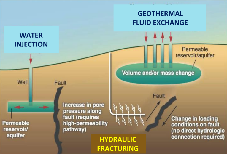
Separately, the characterization of deep disposal aquifers has examined reservoir properties, geomechanical stresses and structural elements to identify which disposal sites are best suited to safe operation. This enables operators to select preferred locations and design programs accordingly.
The result is continuous improvement in practice. The research provides a scientific basis for designing hydraulic fracturing programs and wastewater disposal operations with lower seismicity risk, and it gives the B.C. Oil and Gas Commission the evidence it needs to set appropriate operating conditions. This is what a mature, science-led sector looks like.
Carbon capture: The storage potential
The third pillar of Dr. Hayes’ presentation addressed greenhouse gas emissions and the potential for carbon capture and storage (CCS) in northeast B.C. The Northeast B.C. Geological CCS Atlas characterized and mapped CO₂ storage potential in deep saline aquifers and depleted oil and gas reservoirs. The median-case finding: 4.2 gigatonnes of storage capacity.
That figure is significant. It means that the same geological corridor that produces natural gas also has the subsurface characteristics needed to permanently store large volumes of carbon dioxide. The atlas informs decisions about where CCS projects should be sited, taking into account the locations of major emitters and existing pipeline and processing infrastructure.
By contrast, a parallel study of the Central Interior’s Nechako Basin found only small, high-risk storage capacity, owing to unfavourable geology. This kind of comparative assessment is exactly what policymakers need: not every basin is suited for CCS, and knowing which ones are and which are not prevents costly mistakes.
The alignment between Montney production and CCS potential is not coincidental. The deep sedimentary formations that trap hydrocarbons are, in many cases, the same formations that can trap injected CO₂. Responsible development of the gas resource and deployment of carbon storage technology can proceed in parallel, using much of the same geological knowledge and infrastructure.

B.C.’s unconventional gas resource estimates
Formation / basin
Estimated marketable gas (Tcf)
Montney Formation
449
Liard Basin
219
Horn River Basin
78
Total
746
What Resource Works concludes
Dr. Hayes’s presentation to the Geoscience BC Energy Webinar told a story of science, investment and results. Across water management, seismicity monitoring and carbon storage, the picture is the same: a sustained program of public geoscience, carried out by qualified researchers and funded collaboratively, is delivering continuous improvement in how B.C.’s unconventional gas resources are developed.

Geoscience BC’s role in this is distinctive. It engages academic and industry expertise to produce public geoscience that serves everyone — operators, regulators, policymakers and the public. The research it funds builds the knowledge base that makes responsible development possible and measurable.
The record speaks for itself. Aquifer mapping has given operators and regulators a detailed understanding of water resources across the Montney development area. Seismic monitoring networks are producing the data needed to design lower-risk programs. Carbon storage capacity has been characterized and mapped, positioning northeast B.C. for large-scale CCS deployment. In each case, the science leads and the practices improve.
The Geoscience BC program is evidence that B.C.’s upstream gas sector is committed to continuous improvement at every level — from the wellpad to the regulator’s office. That commitment is one reason the sector enjoys broad public support in the province.
Responsible resource development is an ongoing process, not a destination. The work continues, it is grounded in science, and it is producing results. The Montney story is a good one. It deserves to be told.
About Resource Works
Resource Works Society is a non-partisan research and education organization based in British Columbia. It promotes informed public discussion about the responsible development of natural resources. Its research papers present evidence from credible sources to support fact-based policy dialogue.
Resource Works News
References
Geoscience BC, Unconventional Gas Resources of British Columbia. Resource estimates based on assessments by B.C. MEMPR, the Geological Survey of Canada and industry. See geosciencebc.com/energy.
Geoscience BC Peace Project. Airborne geophysics, water well data and shallow bedrock mapping of aquifers in the Montney development area. https://www.geosciencebc.com/major-projects/peace/
Geoscience BC Horn River Basin Aquifer Project. Characterization of deep saline water-bearing formations for sourcing and disposal. https://www.geosciencebc.com/major-projects/horn-river-basin/
Geoscience BC induced seismicity monitoring and characterization projects. See geosciencebc.com/energy for project reports on seismic monitoring, geological factors and completion practices.
Geoscience BC, Northeast B.C. Geological Carbon Capture and Storage Atlas. Median-case storage capacity of 4.2 gigatonnes of CO₂. https://www.geosciencebc.com/projects/2022-001/
Geoscience BC, Central Interior (Nechako Basin) CCS study. Found only small, high-risk storage capacity due to unfavourable geology. geosciencebc.com/energy
Dr. Brad Hayes, Senior Geoscience Advisor, GLJ. Presentation to the Geoscience BC Energy Webinar, June 22, 2026.
Share This: