CDN NEWS |
  US NEWS


By closing the north, Ottawa and Victoria may have opened the only pipeline route that can actually get built
By Stewart Muir
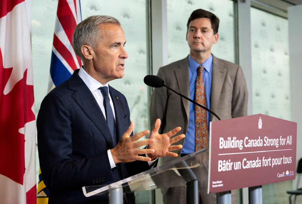
Prime Minister Mark Carney speaks during an announcement with B.C. Premier David Eby in Vancouver, on Thursday, July 2, 2026. THE CANADIAN PRESS/Ethan Cairns
Today British Columbia stands at the centre of two announcements that will shape the Canadian energy economy for a generation. This morning, Prime Minister Mark Carney and Premier David Eby unveiled a memorandum of understanding committing more than $150 billion in new investment with B.C. as the “linchpin” — including $3.5 billion for the North Coast Transmission Line and $500 million to expand copper production at Red Chris. This afternoon, Carney joins Alberta Premier Danielle Smith in Calgary to unveil the details of a proposed million-barrel-per-day oil pipeline to the West Coast.
The MOU retains the northern tanker ban — a constraint whose strategic implications have long been obvious, except for some whose view of B.C. was partially obscured by the Rocky Mountains and who until even recent weeks had not fully reckoned with it nor seen it as insuperable. Eby has now confirmed what the ban always implied: there is “no way” a northern oil pipeline gets built under this framework.
That is not new information for those who have been paying attention. But it is now official. And it changes the geometry of everything that follows.
If the north is closed, the south is open. And the south has a track record that almost nobody is talking about.
The corridor that already works
The Trans Mountain expansion crossed the Lower Fraser Valley to tidewater without decisive corridor-killing opposition from local First Nations or communities — and with significant Indigenous partnership agreements in place. That fact, unremarked upon in most coverage of the pipeline debate, is the single most important data point in the conversation about a second oil pipeline to the coast. Opposition from some First Nations and municipalities existed and was litigated vigorously. But it did not stop the pipeline. The corridor held.
The Musqueam Nation withdrew from the Federal Court of Appeal challenge to TMX in 2017, choosing instead to pursue a direct relationship with the Crown and the proponent. Trans Mountain ultimately signed 43 mutual benefit agreements with Indigenous communities along the corridor, 33 of them in British Columbia, sharing in excess of $400 million. The Lower Fraser Valley First Nations — the communities through whose territories the pipeline actually passes — were not the opponents. They were the partners.
This is consistent with what we have documented through the Indigenous Partnerships Success Showcase over the past six years and in our Nations on the Record research: the Indigenous communities closest to resource infrastructure are frequently its strongest supporters, because they see the economic participation that comes with it. It has been extensively reported that the campaign to block Canadian oil exports received significant foreign funding, some of it traced to interests that stood to benefit commercially from keeping Canadian barrels off world markets. The tanker ban itself, the single policy instrument that closed the northern corridor, was a priority objective of these campaigns long before it became law.
The work nobody knows about
The success of the TMX corridor should not be taken lightly or for granted. That pipeline did not get built because opposition melted away. It got built because of an extraordinary degree of coordination within governments — federal, provincial and regulatory — that persisted across changes in administration and political mood. It got built because persistent and visionary business executives at Kinder Morgan and then the federal Crown corporation stayed the course through years of legal challenges, cost overruns and political uncertainty. And above all, it got built because of quiet First Nations leadership — the leaders who negotiated mutual benefit agreements, who chose partnership over protest, who secured economic outcomes for their communities without press conferences or marches and whose names most Canadians will never know.
What almost no one outside government is aware of is the extent of the federal effort, led by Natural Resources Canada, to sustain those relationships through and after the approval process. NRCan established a Phase IV Partnership Office in 2019 specifically to coordinate Crown outreach to the 129 Indigenous communities with access to TMX accommodation measures. The office engaged directly with Lower Fraser communities on custom commitments, accommodation measures and ongoing dialogue.
The process was imperfect. NRCan’s own evaluation rated Indigenous groups’ assessment of the engagement as “poor” to “fair,” and the office’s communications products were delayed or underused. But the infrastructure of relationship — the agreements, the accommodation measures, the ongoing dialogue — exists. It was built, painstakingly, over five years. A southern pipeline corridor would not be starting from scratch. It would be building on a foundation that is already in place, with communities that have already demonstrated their willingness to participate.
A second pipeline through this corridor will require the same combination: government coordination, executive persistence and Indigenous leadership. None of those things are automatic. Each was hard-won the first time and will need to be earned again. Anyone who looks at the TMX precedent and assumes the southern route is easy is misreading the history. The corridor works — but only because people made it work, at considerable personal and institutional cost.
The tanker question is answered
Six years ago, when the tanker debate was at its peak, I led a team that produced the Citizen’s Guide to Tanker Safety and Spill Response on British Columbia’s South Coast — the first effort to gather comprehensive information about oil tanker traffic, safety measures and spill response capacity into one concise, plain-language document. The guide documented the investments in marine safety that accompanied TMX: $150 million into the Western Canada Marine Response Corporation, more than 100 new personnel, 40 new custom-built response vessels, and a spill response regime that is among the most robust in the world.
Those investments are in place. The response capacity exists. The Burrard Inlet terminal is operational and handling tanker traffic today. A Roberts Bank crude terminal would not be identical to Westridge — it would require its own terminal design, navigation protocols, emergency-response planning and regulatory approvals. But the marine safety framework, the response fleet and the regulatory architecture that governs tanker operations on B.C.’s south coast are established and operational. The tanker safety question has been materially advanced by the operating record and spill-response investments now in place.
What the MOU actually did
Strip away the politics and the MOU does two things. It closes the northern route — tanker ban stays, no oil pipeline through the north. And it includes language requiring that B.C. “must share meaningfully” in the economic benefits of any new pipeline, including an annual royalty payment and an environmental response fund.
That second point is the one to watch. It is reasonable to infer that a province that expected no pipeline to be built would not negotiate royalty terms for one. That language reads less like a wall and more like a price tag.
There will be bitter disappointment across the northern corridor today. First Nations who saw earlier pipeline concepts as generationally beneficial and environmentally manageable — Nations that negotiated in good faith, that planned for the revenue, that built their economic futures around participation — have had those hopes sacrificed to the aims of a powerful alliance of domestic and foreign environmentalists. Some might say there could be an expanded southern route without closing off the possibility of a future northern route. There is not much worth discussing on that front today, except to note that it happened and that the people it happened to deserve better than silence. On the other side of the same corridor, however, the proponents of northern LNG projects — LNG Canada Phase 2, Ksi Lisims, Cedar — are breathing a sigh of relief. A northern oil pipeline terminus at Prince Rupert would have dragged every LNG project into a bitter, generalized fight over tanker traffic and industrial development on the north coast. With the oil pipeline debate redirected south, the LNG corridor can proceed on its own merits, without becoming collateral damage in someone else’s battle.
The effect: the MOU funnels the entire pipeline conversation south — into the one corridor where the partnerships, the safety infrastructure and the social licence already exist. By taking the northern route off the table, it cleared the path for a pipeline that is easier to build, easier to defend and harder to oppose.
TMX has a capacity of 890,000 barrels per day. In Q1 2026, it averaged 737,000 bpd — 83 per cent utilization — and was expected to approach full capacity by June. The ceiling is close. Pipeline optimization across the western system — TMX, the Enbridge Mainline and South Bow’s Prairie Connector — could add up to 1.3 million barrels per day of additional export capacity. But optimization has limits. The demand for a second corridor is not in question. The southern route is now the only route in play.
The question nobody is asking
Everyone will cover today’s politics. The commentators will assess who won and who lost. Alberta will claim vindication. B.C. will claim protection.

The structural question underneath is simpler: did Carney and Eby just solve the pipeline problem by accident? By closing the north, they eliminated the route that would have triggered the fiercest opposition and left standing the one corridor with a proven track record. That is not a constraint. It is a clarification. Canada has spent 15 years arguing about where to build pipelines to the Pacific. The MOU narrows the answer to the corridor where the social licence already exists. The politics look like a concession to B.C. The geography looks like a decision that Alberta can live with — because the southern corridor actually reaches tidewater, with the partnerships and the safety record to prove it works.
What it takes for this to be worth it
For Canada to capture the full value of a southern corridor, the scale has to match the ambition. A million barrels per day to tidewater. That means a pipeline larger than TMX — and a marine terminal that can load the ships the global market demands.
The existing Westridge terminal in Burrard Inlet handles Aframax-class tankers, constrained by the draft limits at Second Narrows Bridge — controlling depth 15 metres, far too shallow for the world’s largest crude carriers. A million-barrel operation needs VLCCs — Very Large Crude Carriers — and a fully loaded VLCC draws 20 to 23 metres of water.
Roberts Bank, in Delta, already has the depth. Every commercial berth in Canada has what mariners call a “controlling depth” — the shallowest point a ship must pass over to reach the berth safely. It is the number that determines whether a port can handle a given vessel: if the ship’s draft is deeper than the controlling depth, the ship cannot go there. The Pacific Pilotage Authority, which governs vessel movements on the B.C. coast, publishes these figures for every berth. Current Pacific Pilotage Authority data show Roberts Bank Westshore 1 at 22.2 metres and Westshore 2 at 19.0 metres. A fully loaded VLCC can draw up to 22.5 metres. The deeper berth is close to VLCC range; the shallower one is not. But the critical point is that Roberts Bank already has deep-water infrastructure in the right ballpark — and with targeted investment in berth deepening, turning basin design and terminal engineering, it is the only location on B.C.’s south coast with the potential to handle the world’s largest crude carriers without the bridge restrictions that permanently limit Burrard Inlet. The port already hosts the busiest coal export terminal in North America (Westshore Terminals, handling more than 20 million tonnes per year) and a major container facility (Deltaport). It has the deep-water access, the existing industrial zoning and the marine infrastructure to accommodate a crude oil terminal capable of loading VLCCs directly. No bridge restrictions. Open water to the Strait of Georgia.
This is where the story gets interesting — and where it gets diplomatic.
Perspective on tanker traffic
The Strait of Juan de Fuca is already one of the busiest commercial waterways on the Pacific coast. Approximately 8,300 deep-draft vessels transit the strait annually — bulk carriers, container ships, tankers, vehicle carriers and others — serving both Canadian and American ports. About 5,500 of those are bound for Canadian destinations and 3,700 for Puget Sound. Tankers already account for roughly 530 transits per year: approximately 328 calling at Washington State’s oil refineries and 202 at Canadian terminals in Burrard Inlet.
A VLCC operation from Roberts Bank carrying a million barrels per day would add approximately 120 to 150 tanker transits per year — because VLCCs carry four to five times the cargo of an Aframax. That is a meaningful increase in tanker traffic, and it demands serious attention to safety, orca protection and navigational management. But it is an increase of roughly two to three per cent on total deep-draft vessel movements through a strait that already handles thousands of commercial ships annually, including a brisk tanker trade serving the Washington State refinery complex. The strait is not a pristine wilderness being industrialized for the first time. It is a working waterway that has accommodated commercial shipping for more than a century.
The strait, the whales and the diplomacy
VLCCs departing Roberts Bank bound for Asia have two routes to open ocean: the Haro Strait, running west of the San Juan Islands entirely within Canadian waters, or the Rosario Strait, threading between the San Juan Islands through American waters. Every mariner will tell you both are navigable. The question is political, not nautical.
The southern resident killer whales — the endangered orca population whose protection was the single largest regulatory obstacle to TMX — are central to this question. J-pod, the most resident of the three pods, ranges across the entire Salish Sea: from the Strait of Georgia as far north as Campbell River and Texada Island, through the Strait of Juan de Fuca and Puget Sound, and along the outer Pacific coast from Southeast Alaska to California. They are not confined to a single strait. They move through the same waters that serve both Canadian and American shipping.
The Haro Strait is the all-Canadian route, but it passes through key orca foraging habitat. The Rosario Strait is of less concern but invites opposition from Washington State — where former governor Jay Inslee established a legacy of aggressive environmental policy on marine protection, and where his successors have made clear that any increase in oil tanker traffic through the Salish Sea will be contested.
In the Canadian shipping lanes, the maritime sector has already focused substantial effort on managing this coexistence. The ECHO program, coordinated by the Vancouver Fraser Port Authority, implements voluntary vessel speed reductions when the whales are in the vicinity — one of the most advanced vessel-noise mitigation programs in the world. A Roberts Bank crude terminal serving VLCCs would produce fewer individual vessel transits than the same volume carried on smaller tankers — a VLCC carries four to five times the cargo of an Aframax. Fewer ships, larger loads, less cumulative noise. Combined with routing protocols, seasonal transit windows and continued investment in the marine safety infrastructure documented in the Citizen’s Guide, the orca impact of a VLCC operation could be managed to a standard equal to or better than current TMX tanker traffic through Burrard Inlet.
The boundary question itself is the oldest on the Pacific coast. In 1872, Kaiser Wilhelm I of Germany arbitrated the dispute between Britain and the United States over whether the international boundary ran through the Haro or the Rosario Strait — the aftermath of the Pig War, the only armed confrontation between the two countries in the Pacific Northwest. Wilhelm ruled for the Haro Strait, placing the San Juan Islands within American territory and establishing the maritime boundary that governs these waters to this day. A hundred and fifty-four years later, the same two straits present the same question in a different form: does Canadian crude reach the Pacific via an all-Canadian route, or via an American strait that will provoke a cross-border confrontation?
The diplomatic complexity is real. Canada does not need American permission to ship Canadian crude through Canadian waters — but shared traffic management systems, treaty obligations and Salish Sea politics will all require sustained diplomatic attention. The prize — a million barrels per day reaching Asian markets from a deep-water Canadian port — justifies the effort.
The gift for Washington — and for Washington
There is one more dimension to the southern corridor that nobody in Ottawa or Victoria appears to have noticed, but that someone in the White House would grasp immediately.
Just south of the border, within sight of Roberts Bank, sits the largest refinery complex in the Pacific Northwest. Washington State’s five refineries — bp’s Cherry Point (225,000 barrels per day), HF Sinclair’s Puget Sound refinery (up to 160,000 bpd), Marathon’s Anacortes facility (119,000 bpd) and two others — have a combined capacity of nearly 640,000 barrels per day. They are the economic backbone of Whatcom and Skagit counties.
These refineries have been fed by Canadian crude since 1954, when the Trans Mountain Puget Sound Pipeline began shipping oil across the border at Sumas. Canadian imports nearly doubled from 110,000 barrels per day in 2009 to 195,000 in 2016, and have continued to grow as Alaska North Slope production — once the primary feedstock — has collapsed from over two million barrels per day in 1988 to roughly 525,000 today. Washington’s refineries are already dependent on Canadian oil. A southern pipeline corridor to Roberts Bank, with a spur or marine transfer capability to Puget Sound, would convert that dependency into permanent, secure, overland supply.
If Mark Carney were quick on his feet, he would place a call to Washington before Friday. The pitch writes itself: a million barrels per day of Canadian crude reaching the Pacific coast, with the capacity to guarantee feedstock security for every refinery in northwest Washington. For a president who threatened tariffs on Canadian crude while his own refineries depended on it, this is the infrastructure that resolves the contradiction.
The timing could not be better. As the Freedom 250 Independence Day celebrations unfold in Washington, D.C. this Friday, there is a certain appeal to a Canadian prime minister offering the American president exactly what he asked for: secure, overland, Canadian crude oil supply to American refineries, announced on the Fourth of July. The fireworks, we understand, are already planned.
The prize
If Canada gets all of this right — the pipeline, the terminal, the maritime protocols, the First Nations partnerships, the diplomatic dimension — it becomes as close to an energy superpower as it is possible to become. A million barrels per day of Canadian crude reaching Asian markets from a deep-water Pacific port. LNG flowing from Kitimat and eventually Ksi Lisims. Critical minerals from the interior. Copper from the northwest. The transmission infrastructure to power all of it.
The TMX corridor proved that when First Nations are genuine partners and the safety infrastructure is world-class, a pipeline can cross metropolitan Vancouver to tidewater without the country tearing itself apart. Today’s MOU points directly at that corridor. The question is no longer whether Canada can build another pipeline to the Pacific. It is whether the leaders who signed today’s agreement are willing to follow the logic of what they just created — all the way to Roberts Bank, through the strait, and out to the world.
Stewart Muir is the President and CEO of Resource Works Society and the co-author of the Citizen’s Guide to Tanker Safety and Spill Response on British Columbia’s South Coast.
Share This: