CDN NEWS |
  US NEWS


When: February 8 @ 12-1pm MST
Register here.
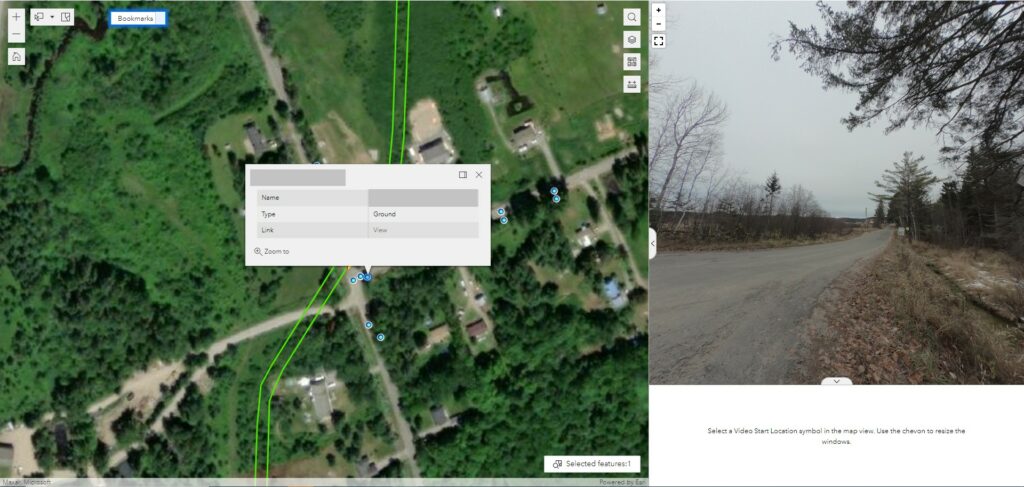
Using GIS to create, manage, analyze, and map all kinds of data — then crafting it into one seamless, tailored web portal — we make massive amounts of information more accessible than ever before to clients in nearly every industry.
Backed by a skilled and certified staff of GIS analysts and developers, our custom portals are built to fulfill precise requirements for functionality and adapt to the specific needs and goals of each client.
Connecting documents, panoramic images, still images, vector data, and more, we’ll help you integrate the data you need, how you need it, in an intuitive, visual platform that helps drive smarter operations and deliver safer, more sustainable projects through max collaboration.
Bonus content: Drones! Or what we like to call remotely piloted aircraft systems (RPAS) or unmanned aerial vehicles (UAVs). During this webinar, we’ll also discuss GeoVerra’s top-of-the-line aerial equipment and how our teams are using the technology to create customized solutions for clients and collect detailed, visual data like never before. Our diverse equipment and licensed pilots help clients gain efficiencies and reduce time in the field, ultimately saving money and mitigating safety risks.
Who is this for? Project managers, site supervisors, engineers, and construction managers who work across all industries.
Presenters:
Cindy Genkin | National Manager, Applied GIS
Cindy Genkin has more than 20 years of GIS and cartographic experience. Her work experience has included coordinating both small and large-scale mapping and GIS projects using a wide variety of data types and applications. Cindy has extensive knowledge of data structure, analysis, and applying this knowledge to create GIS web applications. As National Manager of Applied GIS, Cindy and her team have worked on a variety of project disciplines including oil and gas, transportation, infrastructure and environment for both clients in the private and public sectors. Many of these multi-disciplinary projects combine data, logistic concerns and ever-changing requirements to bring together a GIS web application and cartographic products that support day-to-day project needs with high-level decision making.
Leon Hanlan | National Manager, Geospatial and Director of Flight Operations
Leon Hanlan is a graduate of the Civil Engineering Technology Geomatics program at Red River College. He has 13 years of experience in the surveying and geomatics industry, and has 16 years of experience in management prior to joining our team. He began his Geospatial career as a field representative before making the transition to Project Manager, then to Division Manager of Special Projects and currently as National Manager, Geospatial and Director of Flight Operations. In his current role, Leon is responsible for the GeoVerra RPAS program, assisting with troubleshooting all Geospatial projects, planning and new technology direction and development. He also ensures client demands and expectations are met, as well as overseeing the daily operations and providing support for Project Managers and field crews on all Geospatial projects.
To learn more about one of Canada’s largest surveying and geomatics firms, visit www.geoverra.com
Share This: