


 CDN NEWS |
  US NEWS


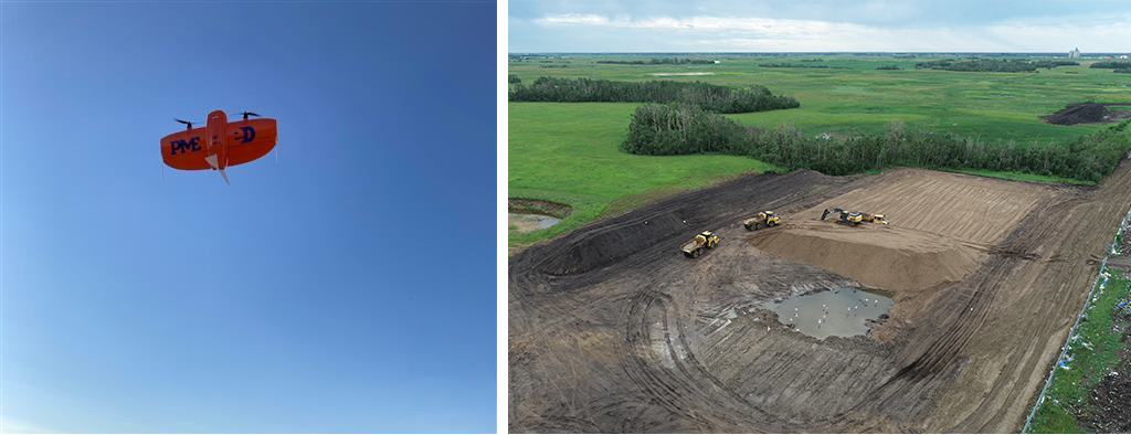
Did you know the legal height limit of flying a drone in Canada is 120 meters? PME Inc. executes our survey flights between 90 and 120 meters depending on the site and proximity to aerodromes (airports or airfields).
Through the use of our drones, we can visually capture our projects from start to finish. We have three types of drones enabling us to customize each flight depending on the need and outcome we are wanting to achieve.
The drones we use include:
- The DJI Mavic 2 Pro: this is a small quadcopter that we use for imagery or video of projects. This drone can fly for approximately 20 minutes at 25 km/h.
- DJI Matrice 300 RTK: this is a large quadcopter for survey flights. The advantage of this drone is the RTK (Real Time Kinematic) accuracy and much longer flight times of up to 1 hour at 40km/h.
- The Wingtra Gen II: The Wingtra is a fixed-wing drone which allows us to drone very large projects as it flies approximately 50 km/h for up to 1 hour.
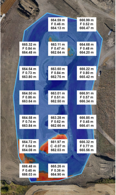
After the pictures have been taken, we use imagery processing tools to scan and prepare the data from the drone. We export the data and create reports to assess tracking and accuracy. When we export the drone footage, we use is high-resolution imagery and these images are georeferenced and used in our reports to show real world conditions and visuals.
PME uses drones to survey areas to measure the worksite by square metres. A sample of these measurements would be stripped topsoil area, asphalt placed, sidewalk areas, and mulched tree clearing. We also use the drone data to measure lengths of curbs, fences, paint lines, and culverts. The drone data is also used to calculate volumes some examples are pile surveys, progress monthly volumes, volumes of borrow pits, and any other volumetric calculations.
Overall PME drones are used to document the construction process allowing us to see the entire site ensuring our safety, and that quality standards are met.
Share This:


AI INSIGHT: Can Alberta Become the Compute Capital of Canada? – Maureen McCall