


 CDN NEWS |
  US NEWS


Building on our significant experience operating in the north, Challenger Geomatics has formed strong relationships with many local Indigenous partners, and we are pleased to be celebrating, alongside our Inuvialuit partners, this important milestone.
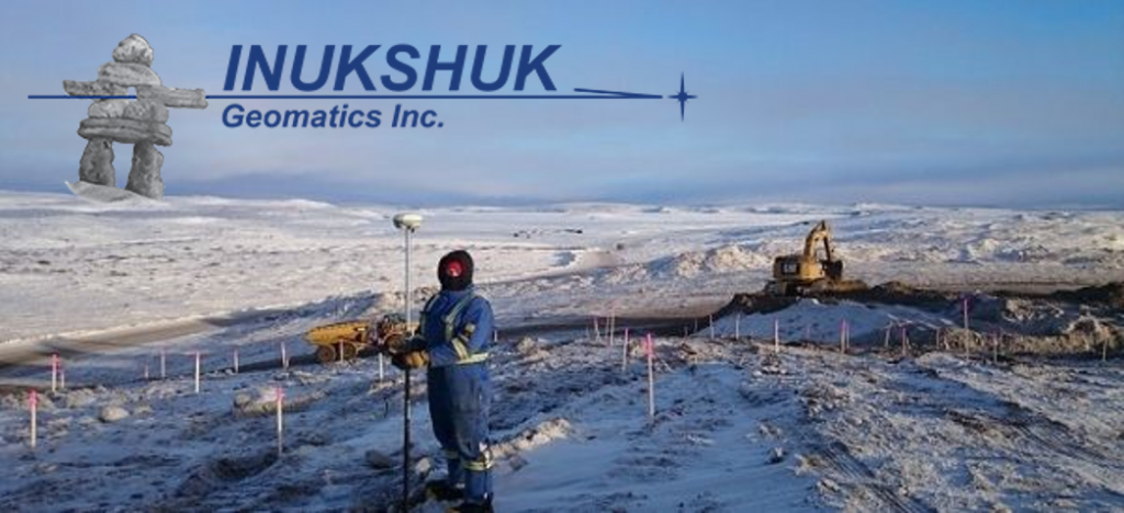
Inukshuk Geomatics is an Indigenous-owned company providing professional geomatics services in the Inuvialuit Settlement Region of the Northwest Territories. This includes the communities of Inuvik and Tuktoyaktuk. The company is 51% owned by Inuvialuit Development Corporation (IDC). Challenger Geomatics Ltd. owns the remaining 49%.
In the year 2000, there was significant interest in accessing oil and gas resources in the Canadian Arctic. Challenger had already been involved in exploration activities and our client PetroCanada had a significant project in the Mackenzie Delta. They wanted to ensure Inuvialuit and Indigenous participation. Challenger began to have discussions with local people, eventually negotiating an agreement to found this new company at the end of that year.
Inuvialuit Development Corporation is pleased to celebrate the accomplishment of over 20 years in partnership as Inukshuk Geomatics with Challenger, which has continually demonstrated its commitment to the Region, working with and alongside local people and business and offering skills capacity, while the completed work significantly contributes to many of our important infrastructure projects.– Patrick Gruben, IDC Chair
Heavily involved in those early days of Inukshuk Geomatics was Ron Robinson (retired). “Inukshuk Geomatics has managed to endure and thrive largely as a result of the people involved. We’ve had some great people in the north, often having the same staff returning season after season. The mutual respect and giving back to the community evolved into close friendships between Challenger staff and their local Inuvialuit counterparts.”
The communities of Inuvik and Tuktoyaktuk have grown substantially since this partnership was founded (new hospital, airport upgrades, housing, industrial and commercial development), Challenger has been able to provide expertise and assist local government in meeting their sustainable development goals.
One of the most significant infrastructure developments in recent years has been the construction of the Inuvik-Tuktoyaktuk Highway. For E. Grubens Transport and Inukshuk Geomatics, building the northern 60 km had its fair share of challenges. Over 4 years, Inukshuk Geomatics provided survey support for the highway’s design, identified gravel pit locations and access, provided construction survey support, completed the largest legal survey executed on Canada Lands in 2017, and conducted the final as-built survey.
I’ve had the good fortune of working with the Inuvialuit in the ISR for the last 15 years. A true highlight was two winters that I spent scouting the Inuvik to Tuktoyaktuk highway prior to construction. My Inuvialuit guides had an intimate knowledge of the landscape that was truly impressive. I’ll always remember the long days on snow machine in beautiful country.– Paul Burbidge, President and CEO of Challenger Geomatics
As part of this relationship, Inukshuk Geomatics regularly uses Inuvialuit businesses for accommodation, transportation, supplies, etc. and hires Inuvialuit beneficiaries whenever possible. Having local wildlife monitors and their knowledge of the land has been extremely valuable.
Ensuring local communities can fully participate in geomatics activities on their land has always been a high priority for Challenger. Technical staff have delivered surveying and geomatics training in these communities and partnered with local colleges to ensure local residents are able to work on these projects as survey assistants.
“IDC expects Inukshuk Geomatics will only continue to contribute and advance in our partnered work which is a critical basis of the road upgrading, reclamation and development projects needed to build our communities,” explained Patrick Gruben. “We look forward to the training opportunities and technical surveying expertise Inukshuk Geomatics will deliver in the Region over the next decades.”
The region holds special significance to Challenger as well. Though officially founded in Alberta, the formation of Challenger Geomatics is largely the result of connections made on the Mackenzie River Delta and Beaufort Sea. Dave Thomson (Executive Vice President and past President) and Tim Harding (Vice President) and several other early Challenger employees worked together on projects here before deciding to start their own company in 1984.
“Its very gratifying that we’re still making contributions through Inukshuk Geomatics nearly 40 years later,” said Dave Thomson.
Inukshuk Geomatics along with Sahtu Geomatics (founded in 2012) are among the few Indigenous companies permitted to practice land surveying on Canada Lands by the Association of Canada Lands Surveyors (ACLS).
Notable Projects
- Inuvik-Tuktoyaktuk Highway
- Distant Early Warning (DEW) line site reclamation
- Mackenzie Gas Project
- Tarsuit Caissons decommissioning and reclamation
- Mould Bay weather station road upgrades and reclamation
- Topographic surveys and buried line locates
- Wellsite surveys and drilling program support
- Mine reclamation projects
- Pipeline Scouting and Preliminary Design Surveys
For more information about Challenger Geomatics, please visit: www.challengergeomatics.com
Share This:


COMMENTARY: Canadians Should Decide What to do With Their Money – Not Politicians and Bureaucrats